Read next
The latest news, updates and expert views for ambitious, high-achieving and purpose-driven homeowners and property entrepreneurs.


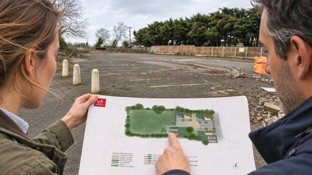
A Grey Belt assessment looks simple until you reach the hidden test.
The land is in the Green Belt, it is previously developed, and it is enclosed by houses on three sides. It looks compromised, so surely it is Grey Belt?
It may be. But appearance is the wrong place to start.
A derelict yard can fail because it sits in the gap between two towns. An open field can pass because housing encloses it and it adds nothing to sprawl.
Annex E of the NPPF 2026 asks what the land does for the Green Belt, not how it looks. Inspectors are now applying its criteria at appeal, and a clear pass on the land is only half an answer.
In my experience, the assessments that go wrong rarely misread the policy text. They misapply it: treating a village as a town, relying on a boundary too slight to contain development, or stopping at Grey Belt status instead of testing the scheme that follows.
In this article, I explain how to test the land, then the scheme, and what the assessment report must show before you price, promote or apply for planning permission.
In England, a Grey Belt assessment tests both the land’s classification and the proposed development’s compliance with the relevant policy route. It asks two questions, in a fixed order:
A site may qualify as Grey Belt yet fail the development tests in policy GB7(1)(g). These cover unmet need, sustainable location, the effect on the remaining Green Belt and the Golden Rules where applicable. Land that does not qualify as Grey Belt may still have another route to development.
Under the NPPF 2026, Grey Belt status does not remove land from the Green Belt or grant planning permission. The route can be tested through a planning application without waiting for a new local plan, but the land’s classification and the scheme’s acceptability require separate consideration.
The land test examines purposes (a), (b) and (d) in policy GB2 using the criteria in Annex E. The annex sets the method for Green Belt assessments informing local plans under GB2(3). It refers to assessment areas, which need not follow the boundaries of an individual development site.
Recent Grey Belt appeal decisions show inspectors applying those criteria to individual sites and examining whether the assessment boundaries are justified. Before grading the land’s contribution, your planning consultant should justify the selected assessment area and the evidence supporting that choice.
Land meets the definition if it is within the Green Belt and does not strongly contribute to any of purposes (a), (b) or (d). That conclusion depends on an accurate lawful baseline and a defensible assessment area, both established before the contribution is graded.
The planning assessment should confirm the extent of Green Belt land against the adopted policies map, as ownership and marketing boundaries may differ.
Your architects and town planners should establish the lawful use and development history, including any abandonment, using planning records and other evidence of how the site has been used. An emerging plan does not alter the designation until adopted.
Under Annex B, previously developed land includes lawfully developed land occupied, now or previously, by permanent structures and their associated fixed surface infrastructure, including curtilage. It also includes large areas of lawfully developed fixed surface infrastructure, such as hardstanding.
Inclusion of curtilage does not establish that all of it is suitable for development. The definition excludes land last occupied by agricultural or forestry buildings; development subject to restoration provisions; residential gardens, parks, recreation grounds and allotments in built-up areas; and land where structural or fixed-surface remains have blended into the landscape.
The distinction informs the choice of policy route, but it does not settle Grey Belt status. Previously developed land must still pass the relevant purposes test, while undeveloped land is not automatically excluded.
At High Street, Portbury, North Somerset (3378598, dismissed 4 November 2026), the evidence did not establish that the site was previously developed land. The inspector could not establish whether the horse shelter was associated with an agricultural or equestrian use, while the remains of a former compound had blended into the landscape.
The site nevertheless qualified as Grey Belt as other land because it did not strongly contribute to the relevant purposes. The failure of the previously developed land argument therefore did not end the classification exercise.
With the baseline established, the assessment area must be selected. Annex E asks for areas small enough to reveal variations in contribution, subdivided where necessary and often smaller around settlements and transport hubs.
A council study based on a large strategic parcel is relevant evidence, but it does not automatically determine how every smaller site within that parcel performs.
A separate site-level assessment may be justified where development encloses the site, a road, railway, river or change in level separates it from the wider countryside, or its buildings and lawful hardstanding are unrepresentative of the wider parcel.
Subdivision still needs a physical or functional justification. The selected area should be capable of defence whether or not the result helps the applicant; drawing a tighter boundary solely to obtain a favourable rating weakens the assessment.
The North Cray Road, Sidcup, Bexley (6008240, allowed 6 November 2026) decision shows the limit. It concerned a 200MW battery energy storage scheme, and the inspector warned that assessing purposes site by site could produce “excessive granularity”, fragmenting the Green Belt until little appeared to contribute strongly.
The council’s study had not been examined or consulted on, so it was evidence rather than a determinative answer. Its parcel was nevertheless logically drawn and its method rational, making the assessment a strong indicator. The inspector found that the site was not Grey Belt. The appeal succeeded because very special circumstances outweighed the identified harm.
Before commissioning a competing assessment, ask your planning consultant to review whether the council’s study was examined, how its parcels were drawn and whether its reasoning is visible. Those findings determine whether the stronger response is to challenge the method, justify a smaller area or accept that the land performs a substantial Green Belt role.
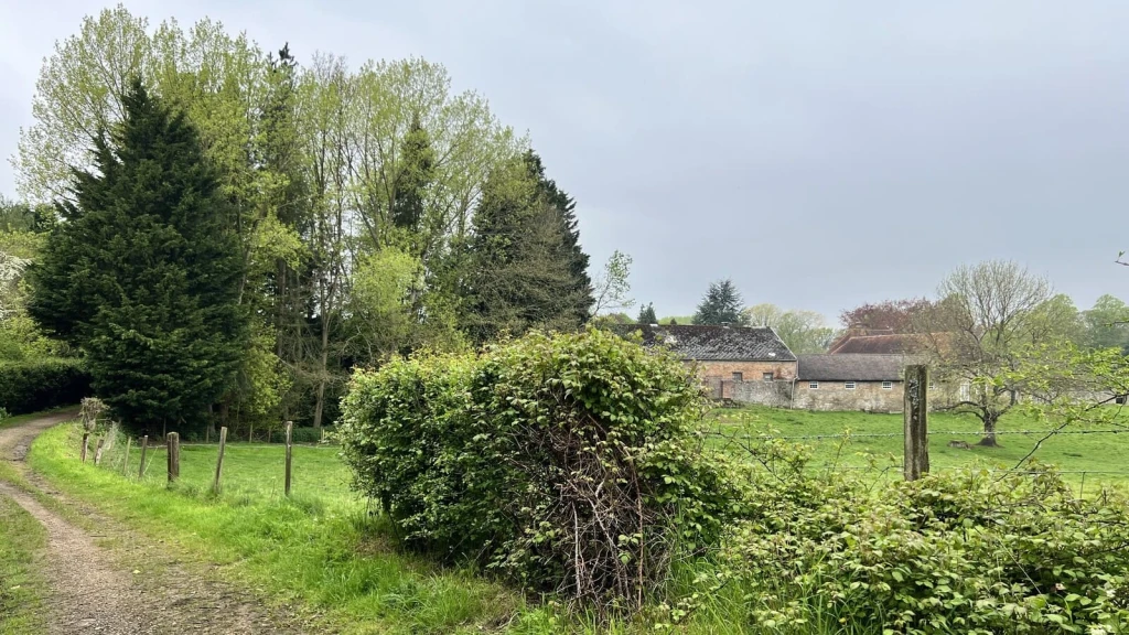
Only three of the five Green Belt purposes determine Grey Belt status: (a) checking the unrestricted sprawl of large built-up areas, (b) preventing neighbouring towns from merging, and (d) preserving the setting and special character of historic towns.
Purposes (c) and (e) do not form part of this classification test. They return when the proposal’s effect on the remaining Green Belt is assessed.
Annex E uses three contribution bands: strong, moderate, and weak or none. For all three relevant purposes, strongly contributing areas are described as likely to be free of existing development. The other illustrative features are summarised below:
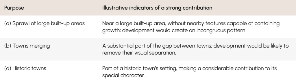
Annex E compares the contribution of assessment areas to sprawl, separation between towns and the setting and special character of historic towns.
A strong contribution to any one of these purposes prevents Grey Belt status. Moderate contributions, even to all three, do not.
The bands remain evidence for a planning judgement, rather than a checklist to tick. An assessment must consider all three purposes and explain the conclusion reached on each.
Annex E confirms that villages are not large built-up areas. Beyond that distinction, there is no universal size threshold, so the settlement’s scale, form and role must be understood in local context.
Open land beside an urban area does not, by itself, make a strong contribution. The assessment must explain whether development would create an incongruous pattern of outward growth and whether existing development or physical features would contain it.
The containing feature needs particular scrutiny. Its stature, continuity and position matter more than the line it creates on a plan.
At Thornhill, Limpsfield, Tandridge (6006369, allowed 29 October 2026), robust and continuous landscaping, together with the road, retaining wall and neighbouring development, provided clear containment. The inspector assessed the site as making a moderate contribution to purpose (a).
At North Cray Road, by contrast, hedges in an open tract of countryside were not of sufficient stature or position to contain development. A boundary feature’s practical effect must therefore be demonstrated, rather than inferred from its presence.
A narrow hedge may define ownership without containing outward growth. A railway, substantial road, river, change in level or established belt of development may provide a more durable limit, but its effectiveness still depends on the site’s actual relationship with it.
Purpose (b) concerns towns, including cities, rather than villages. Land does not strongly contribute merely because it lies between two settlements: both must qualify as towns, and the land must play a meaningful role in their separation.
For land between a town and a village, or two villages, that distinction may settle this particular purpose. It does not settle landscape sensitivity or the proposal’s wider planning acceptability.
Distance is only part of the evidence. The assessment should explain whether the towns would remain visually separate, taking account of the landform, existing development and the experience from relevant viewpoints.
At Fowl Farm, Cuerdley, Warrington (6008814, allowed 26 October 2026), a proposed solar farm extended about 800 metres into a gap of around 1.6 kilometres between Widnes and Warrington. The inspector found that it would occupy a substantial part of the gap and diminish visual separation.
The land also contributed strongly to purpose (a), despite electricity pylons and the nearby power station. It was not Grey Belt. As at North Cray Road, the allowed outcome arose from a case based on very special circumstances, rather than acceptance of the Grey Belt argument.
Purpose (d) concerns historic towns, not villages. A nearby listed building, conservation area or scheduled monument does not, by itself, establish a strong contribution.
The planning assessment should identify the relevant historic town and explain the land’s relationship with its setting and special character. Where the plan area contains no historic towns, Annex E states that a detailed assessment against purpose (d) may not be necessary.
For the strong band, Annex E looks for land forming part of the historic town’s setting and making a considerable contribution to its special character. The assessment should explain the importance of the view, the historic relationship and the function the land performs, drawing on heritage advice where needed.
The report should distinguish the purpose (d) assessment from any separate appraisal of effects on individual heritage assets under the historic environment policies. Land may contribute weakly to purpose (d) while development on it would harm the setting of a listed building.
A heritage impact assessment may therefore be needed even where the land qualifies as Grey Belt. The classification cannot replace the specialist evidence needed to establish whether development is acceptable.
Where the contribution is unclear, your team should identify which missing site evidence could change the conclusion and recommend how to obtain it. Aerial mapping is a starting point, but may not reveal changes in level, the experience from public viewpoints or whether a boundary genuinely contains development.
Your planning team should apply the same scrutiny to the council’s evidence. An older study may use a different method, assess a much larger parcel or overlook site-level variations recognised by Annex E.
The government’s Green Belt Planning Practice Guidance also needs care: at the date of this review, it still contains wording based on the December 2024 definition. Your planning consultant should apply the current NPPF 2026 test where it differs from the older guidance.
At Thornhill, the council’s 2018 assessment rated the wider parcel as making a strong contribution. The inspector gave that overall rating limited weight because the study did not explain how the stronger conclusion followed from its earlier findings.
The lesson applies equally to an applicant’s report. A rating is persuasive only when its reasoning can be followed, and a sound classification must still be tested against the other constraints affecting the proposal.

Yes. Land can meet the Grey Belt definition while other planning constraints prevent or restrict its development. The NPPF 2026 changed where those constraints enter the assessment, rather than removing them.
The December 2024 definition excluded land where policies protecting specified areas or assets gave a strong reason to refuse or restrict development, commonly described as the footnote 7 exclusion. That exclusion has been removed from the definition.
Land affected by a habitats site, a Site of Special Scientific Interest, a National Park or National Landscape, a designated heritage asset, ancient woodland, flood risk or Local Green Space may consequently meet the definition if it passes the purposes test.
The separate policies and statutory protections continue to apply. Flood risk, ecological effects or heritage harm can still make the proposed development unacceptable.
Local Green Space needs particular care: policy HC8 expressly excludes the Grey Belt and previously developed land provisions from the Green Belt tests applied to that designation.
London requires a further distinction. Metropolitan Open Land (MOL) is a separate designation from Green Belt. Adopted London Plan policy G3 affords it the same status and protection as Green Belt, while the unadopted July 2026 draft London Plan states that national Grey Belt policy does not apply to MOL.
Appeal reasoning has differed on the application of Grey Belt policy to MOL. Any reliance on that route therefore needs its own assessment of the adopted plan, national policy, the emerging policy’s weight and the relevant decisions.
For a purchaser, classification and development suitability must be investigated together. A favourable land test has limited commercial value if the proposed use, access or other constraints leave no credible scheme to pursue.
The proposal must pass every applicable limb. Once the land qualifies, policy GB7(1)(g) asks whether this development can use the route. For housing proposals, the four limbs operate as follows:
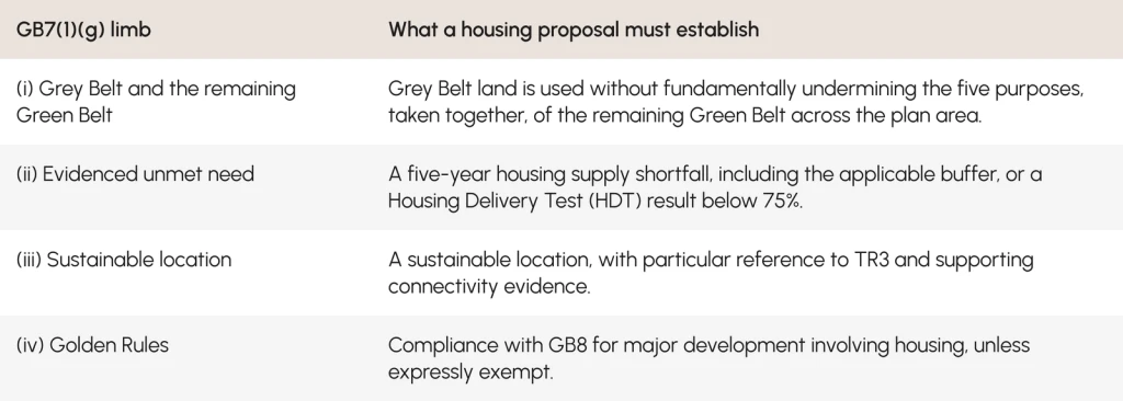
GB7(1)(g) requires housing proposals to satisfy the applicable land, need, location and Golden Rules tests together.
These requirements are cumulative and proposal-specific. Housing need cannot compensate for an unsustainable location, and the same site may pass with one scheme and fail with another.
Passing them makes the proposal not inappropriate development under GB7(1)(g). Under S5(5), qualifying development should be approved unless its benefits would be substantially outweighed by adverse effects when assessed against the national decision-making policies, applying the refusal circumstances in S5(2).
The development plan remains the statutory starting point. Annex A governs the weight given to policies materially inconsistent with the new national decision-making policies.
Green Belt openness can have both spatial and visual aspects. Planting may screen a building without reducing the space it occupies. An open field, meanwhile, may qualify as Grey Belt if it does not strongly contribute to any of purposes (a), (b) or (d). Classification is not determined simply by whether the land looks open or developed.
Policy GB7(1)(g) does not impose a separate requirement to preserve openness. Once every applicable limb is satisfied, the proposal is not inappropriate development and should not be regarded as harmful to the Green Belt. Loss of openness should not then be added as a separate Green Belt objection or used to require very special circumstances.
In practice, we have seen some planning officers continue to assess Grey Belt proposals using older Green Belt policy tests. Your application may encounter the same approach, so the submission should explain clearly which route applies and how its requirements are met.
Your planning consultant should identify the evidence supporting each applicable GB7(1)(g) limb. If openness is raised as a separate objection, they should clarify whether the officer disputes the land’s classification, another development test or an effect governed by a different policy. Where every applicable limb is accepted, the consultant’s response should explain why adding a further openness test would misapply the Grey Belt route.
The physical changes still need to be presented accurately. Replacing an open car park with housing, for example, may reduce hardstanding while adding building volume. Your design team should show both changes through proportionate drawings and viewpoints, coordinated with any specialist assessments needed to address landscape, heritage and amenity effects under the relevant policies.
The layout also remains central to limb (i), which examines what the development would mean for the remaining Green Belt across the plan area.
Limb (i) asks whether the proposal would fundamentally undermine the five Green Belt purposes, taken together, across the remaining Green Belt in the plan area. This is a different assessment from grading the site’s existing contribution to purposes (a), (b) and (d).
At Portbury, North Somerset (3378598, dismissed 4 November 2026), the inspector found that the site’s role in safeguarding the countryside from encroachment was out of proportion to its size. Nevertheless, the proposal would not fundamentally undermine the purposes of the remaining Green Belt across the plan area. It passed this limb, although the appeal failed on other grounds.
The assessment should explain how the proposed scale and layout would affect the surrounding Green Belt. A contained scheme may maintain a defensible limit, while a larger or differently arranged proposal may open a new direction of growth.
Your planning team should support that judgement with evidence of the settlement pattern, adjoining land and the features that would contain development. Site area alone cannot establish whether the wider Green Belt would continue to perform its purposes.
Limb (ii) requires an evidenced unmet need for the type of development proposed. An owner’s preferred use or general market demand is not enough.
For housing, footnote 41 identifies two alternative indicators: the authority cannot demonstrate a five-year supply of deliverable housing sites, including the relevant buffer, or its latest Housing Delivery Test results show delivery below 75% of the requirement over the preceding three years.
If the authority demonstrates the required supply and its HDT result is at least 75%, those indicators do not establish the housing need required by this limb.
Need is also the part of the assessment most liable to change. A monitoring report, an appeal finding or evidence challenging deliverability can alter the supply position.
The 2025 Housing Delivery Test measurement, published alongside the NPPF 2026, is the current national measurement at the date of this review. An authority’s measurement may also be recalculated following adoption of a new housing requirement. Your planning consultant should recheck the applicable HDT result and housing-supply evidence before acquisition and again before submission.
For employment, community or mixed-use proposals, the need evidence must match the development being proposed. Material non-housing elements require an appropriate evidence base; a housing shortfall should not simply be extended to cover unrelated uses.
Limb (iii) requires a sustainable location, with particular reference to transport policy TR3. The assessment must examine how the development would function for the people using it, rather than rely on proximity to a bus stop or station.
TR3 takes account of the vision for the site, the development type and its location. It addresses sustainable movement, accessibility and the use of existing or proposed infrastructure, with significant transport or highway-safety impacts mitigated through a vision-led approach.
In rural areas, opportunities to improve walking, wheeling, cycling and public transport should be taken where they exist and can be supported by the proposal. The evidence should explain what is achievable in that context.
Under TR3(2), the Department for Transport’s Connectivity Tool should be used alongside other relevant quantitative or qualitative evidence. Its output does not replace an assessment of the routes, services and destinations people could realistically use.
A bus stop beside a site may offer little if its service is infrequent or the walk to it is hostile. A station further away may be practically accessible along a safe, direct route.
At Portbury, the two-pitch traveller proposal failed the location test despite nearby regular bus services. Footnote 42 directed particular reference to traveller-site policy HO12; the inspector considered it alongside TR3 and found that crossing heavily trafficked roads, including one without a designated crossing point, discouraged use of the services.
Where sustainability depends on a future bus route or a footpath across third-party land, the planning and transport advisers should establish how it would be funded, secured and delivered. A possible improvement cannot support the same conclusion as one with a credible delivery mechanism.
For major housing, that delivery work must also extend to the Golden Rules.
They apply to major development involving housing, subject to the express exemptions. Policy GB8 covers housing on land released from the Green Belt through plan-making and on sites in the Green Belt subject to a planning application.
For a proposal relying on GB7(1)(g), Golden Rules compliance forms part of the route itself. It needs to shape the scheme before the principle, land value and layout are treated as settled.
The three contributions are affordable housing, necessary improvements to local or national infrastructure, and new or improved publicly accessible green space. GB8(2) requires substantial weight to be given to the importance of complying with them.
The Golden Rules do not apply to traveller sites, development on land released through plans adopted before 12 December 2024, or development granted permission on Green Belt land before that date. The planning consultant should confirm whether the proposal meets the terms of an exemption, since an older permission does not automatically exempt a new scheme.
For the housing thresholds relevant here, Annex B defines major development as at least 10 homes or a site of at least 0.5 hectares. This policy definition differs from the procedural classification of planning applications. The examples show why the dwelling count and complete site area must both be checked:
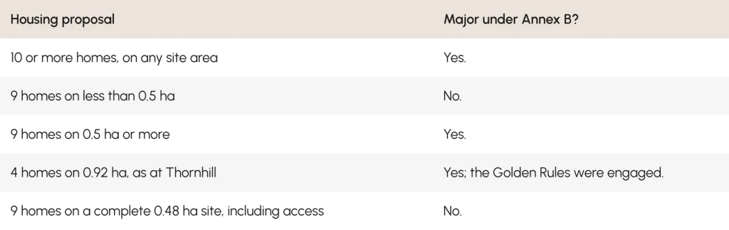
The NPPF housing definition can classify a proposal with fewer than 10 homes as major when its site reaches 0.5 hectares.
Fewer than 10 homes therefore does not necessarily mean a non-major proposal. At Thornhill, the four-home permission in principle engaged the Golden Rules because the site was 0.92 hectares, with their delivery left to technical details consent.
The project team should confirm the genuine application boundary and site area, including access and other necessary land, before advising whether GB8 applies. Below it, GB8 falls away, but the other GB7(1)(g) tests and relevant development-plan policies still apply.
Our work on Green Belt and Grey Belt projects of different scales, from single dwellings to residential masterplans, shows that smaller schemes require the same clarity of site assessment as larger developments. What changes is the proportionate level of evidence and whether GB8 applies.
Two anonymised Urbanist Architecture projects, on which we act as architect, planning consultant and lead consultant, show how those thresholds affect the work that follows.
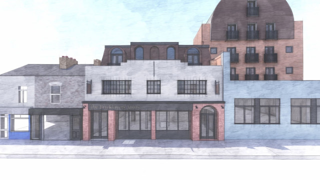
The first is the subject of an outline planning application to convert a former public house into two homes and add seven houses. The whole red line, including access, measures 0.48 hectares.
Existing development and a durable road contain the site, which does not occupy a strategic gap. Effects on a nearby conservation area and Grade I listed building are addressed separately through the heritage strategy.
With nine homes on 0.48 hectares, the proposal is below both housing thresholds, so GB8 does not apply. That conclusion removes one policy requirement; it does not establish the rest of the case.
The application compares the proposal with the lawful public house use and its 47-space car park, showing 808 sqm less hardstanding and 799 sqm of new landscaping. Those figures support the design case, while classification, need and location require their own evidence.
On a former public house site, the loss of the community use also needs its own assessment under policy HC6 and the development plan. Grey Belt status does not settle that question.
The second project is an 88-home masterplan with four neighbourhood retail units, for which we are preparing an outline application. As major housing, it is being developed around the Golden Rules.
Affordable housing, infrastructure and publicly accessible green space are being tested against GB8 and the development plan as the layout evolves. The landscape buffers are intended to define a defensible Green Belt edge, as well as respond to the development’s visual effects.
Both examples connect policy to design decisions. The threshold determines the applicable obligations, while the layout must show that those obligations and the site’s other constraints can be accommodated together.
The planning advice should first establish whether the development plan contains the specific Green Belt affordable housing policy envisaged by GB8 and HO5(1)(a)(ii). Where an applicable policy is in place, its requirement governs the contribution.
Until then, GB8 requires 15 percentage points above the highest existing affordable housing requirement that would otherwise apply, subject to a 50% cap.
If there is no existing requirement, the default is 50%. The cap does not apply to rural exception sites, community-led development exception sites or where a relevant existing local policy requires more than 50%.
For example, an otherwise applicable 30% requirement would normally become 45%. The calculation must follow the policy relevant to the proposal, rather than a percentage assumed from a neighbouring scheme.
The applicable requirement should be confirmed in the planning advice before land value, density and tenure mix are fixed. An appraisal based on unrestricted market housing may need substantial revision once the applicable contribution is included.
The remaining Golden Rules affect both the layout and the development appraisal. A site may physically accommodate buildings while lacking the transport, drainage, education or utility capacity needed to make the scheme acceptable.
Publicly accessible green space must be within a short walk of the new homes, contribute positively to the landscape setting and support nature recovery. It should meet local development-plan standards or, where none exist, the national standards relevant to the proposal, including Natural England’s accessible green space and urban greening standards and Green Flag criteria.
Where a Local Nature Recovery Strategy identifies potential for habitat creation or nature recovery, the proposal should contribute to those outcomes. An area labelled as landscaping is not automatically publicly accessible green space.
Designed early, green space may help define a defensible edge, manage drainage and create usable routes through the scheme. Its location, accessibility and purpose need to be resolved alongside the housing, rather than assigned to whatever land remains.
GB8(3) allows a viability assessment seeking reduced Golden Rules contributions in three circumstances: previously developed land demonstrably burdened by costs associated with its former development that the plan’s viability assessment did not consider; a strategic site; or development of a wholly different type from that tested in the plan.
Even in those circumstances, the maximum possible contribution is expected. Contributions significantly below the policy requirement are acceptable only in exceptional cases, fully evidenced and justified.
The government’s viability guidance also states that the price paid for land is not a justification for failing to comply with planning policy. The contribution assumption should shape the offer, rather than become a problem to resolve after purchase.
Before buying a development site, appoint experienced architects and town planners to assess its development potential and test a realistic scheme against the relevant planning policies. Use their findings to decide what to offer for the land and whether further investment is justified.

A Grey Belt assessment report should set out a realistic strategy for securing planning permission to build in the Green Belt. It should identify the strongest available policy route, explain how the evidence supports it and state which findings could change the recommendation.
The report should distinguish verified findings from assumptions and identify any further work needed. Read alongside the drawings, planning statement and specialist assessments, it should help you decide whether to proceed, commission further investigations, authorise design changes or ask the team to explore another route.
Its main findings should cover:
Assessment area: justify the physical or functional boundaries and compare them with the council’s study, including its method, reasoning and examination status.
Lawful baseline: establish lawful uses and development through planning history, records and dated aerial imagery.
Grey Belt definition: grade purposes (a), (b) and (d), with reasons supported by photographs, viewpoints, topography and historic-town evidence where relevant.
Remaining Green Belt: explain the proposal’s effect on all five purposes, taken together, across the plan area.
Unmet need: date the evidence for the development type, and recheck housing supply and HDT before submission where housing is proposed.
Sustainable location: combine Connectivity Tool output with evidence of usable routes, services and deliverable improvements.
Golden Rules: check dwelling numbers and the complete site area, then explain how applicable contributions would be secured.
Other constraints: identify heritage, flood risk, ecology, trees and the specialist work needed to assess them.
Recommendation: compare credible routes, identify the weakest test and state whether to proceed, obtain evidence, redesign or stop.
The supporting evidence will commonly include:
The adopted policies map, the council’s Green Belt study and relevant planning history.
Lawfulness records and aerial imagery showing how the land has changed.
Site photographs, relevant viewpoints and measured or topographical information proportionate to the question being tested.
Historic environment records and constraints mapping for flood risk, ecology and trees.
The report should state whether its findings rely on desktop material, a site visit or specialist surveys. If boundary strength, views or walking conditions could reverse the conclusion, the team should arrange proportionate verification before recommending that you rely on the findings for acquisition or submission.
Our analysis of more than 20 Grey Belt appeal examples reinforces the need for site-specific classification and a defensible layout. Comparable decisions can test the reasoning, but remain illustrations rather than binding precedent.
The report should end with a recommendation and a decision condition. The professional recommendation should identify the evidence or design change that would justify proceeding, and the adverse finding that would require another route or no further expenditure.
Failure to satisfy GB7(1)(g) closes that route. Other Green Belt exceptions or a case based on very special circumstances may still be available. The main alternatives relevant to housing are:
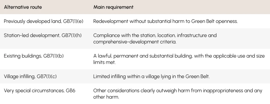
Alternative Green Belt routes depend on different site and proposal characteristics, so failure of the Grey Belt test does not settle the development strategy.
The strongest alternative depends on which Grey Belt test failed and what the proposal can credibly demonstrate. Previously developed land and station-led development deserve particular attention.
The previously developed land route does not require Grey Belt status or evidenced unmet need under GB7(1)(e). It does require the redevelopment to avoid substantial harm to openness.
It also does not automatically avoid the Golden Rules. Although compliance is not written into GB7(1)(e) as a condition of that exception, GB8 still applies to major housing unless an express exemption applies, with substantial weight given to compliance.
The station-led route requires reasonable walking distance of a well-connected station, a close physical relationship with the station or its settlement, sufficient existing or proposed infrastructure and no prejudice to proposals for long-term comprehensive development. Major development must comply with GB8.
Annex B defines the station and walking-distance requirements. Where only part of a site lies within reasonable walking distance, the station exception applies only to that part. A circle drawn around a station cannot establish that the whole site qualifies.
Where no GB7 exception applies, the proposal is inappropriate and requires very special circumstances under GB6. Fowl Farm and North Cray Road succeeded through that route, but both were energy schemes whose benefits differ from those of housing.
A strategy for Green Belt planning permission should identify the strongest available route before the design and land-value assumptions become fixed.

In my view, the assessment boundary is the first assumption to test. A boundary drawn around a yard may suggest containment; including the surrounding field can reveal a very different relationship with the wider Green Belt.
The selected area needs a defensible physical or functional basis, tested against the surrounding land and the council’s assessment. If another equally credible boundary would reverse the conclusion, the assessment should explain that sensitivity before the classification is relied on for an acquisition or application.
I would also expect the team to test the features relied on to contain development. Overstating the strength of a hedge or tree belt can undermine confidence in the wider assessment. Any weakness should be identified while further investigation or a revised layout can still address it.
Higher housing targets help explain the role of Grey Belt in the Government’s planning reforms to increase housing delivery. They increase the pressure to identify suitable land, but the value of that opportunity depends on what a particular site can accommodate and whether the proposed scheme meets the applicable tests.
For major housing, affordable housing, necessary infrastructure and publicly accessible green space form part of the development appraisal. The 0.5-hectare threshold means those requirements can apply to a small number of homes on a generous site.
I would establish the applicable contributions and test a realistic layout before deciding what to offer for the land. Assuming that obligations can later be negotiated away risks paying for development value that the scheme cannot support.
Further design and technical work may be justified where the classification is defensible and there is a credible way to resolve the weakest development test. If the case depends on an artificial boundary, an undeliverable connection or an unsupported viability reduction, ask your team to assess whether an alternative route is credible before committing further resources.
The assessment has done its job when it produces a better development decision, including a well-founded decision not to proceed.
Our Grey Belt assessment is a desktop review and written report. It assesses the planning status, lawful baseline, relevant Green Belt purposes and available policy routes, and identifies where site verification or specialist evidence is needed.
The report can support a pre-application enquiry or planning application, and can be commissioned on its own or as part of a wider feasibility assessment. Where we are appointed as architects, town planners and lead consultants, the findings then inform the masterplan, design and application.
As an RIBA chartered practice bringing residential architects and planning consultants together, we examine planning prospects, design capacity and deliverability as parts of the same development question.
The relationship matters because each finding can change the others. A realistic layout may alter the site boundary and trigger GB8; infrastructure or green-space requirements may reduce the housing capacity; and the resulting obligations may change what the land can support financially.
Bringing those findings together before acquisition terms and design expectations are fixed provides a firmer basis for deciding what to pursue and what further work to commission.
Planning outcomes remain site-specific, and no assessment can guarantee permission. For a site you own or are considering buying, commission an initial review by architects and town planners to identify the strongest credible route, the issue most likely to determine the outcome and the evidence needed before your next commitment.
We look forward to learning how we can help you. Simply fill in the form below and someone on our team will respond to you at the earliest opportunity.
The latest news, updates and expert views for ambitious, high-achieving and purpose-driven homeowners and property entrepreneurs.




We specialise in crafting creative design and planning strategies to unlock the hidden potential of developments, secure planning permission and deliver imaginative projects on tricky sites
Write us a message