Read next
The latest news, updates and expert views for ambitious, high-achieving and purpose-driven homeowners and property entrepreneurs.


Metropolitan Open Land, usually shortened to MOL, has a habit of appearing at exactly the wrong moment.
It often emerges on a site search just as a buyer is preparing an offer, a homeowner is planning an extension, or an owner sees an opportunity to bring an underused yard, clubhouse or sports building back into productive use. At that point, the designation may feel like a full stop.
In my experience, it rarely is.
The first question people ask me is usually: “Can I build on MOL?” It is understandable, but it is not quite the question that decides whether a project has a future.
The more useful question is this: what is the best planning route for this specific site, and what evidence is needed to make that route credible?
The answer does not lie in the MOL designation alone. It lies in the relationship between the site’s existing baseline, the available policy route, and the wider constraints that may still determine whether development is acceptable.
In this article, I cover how MOL differs from Green Belt, why Green Belt policy still matters, and the main routes involving extensions, replacement buildings, previously developed land, Grey Belt, Very Special Circumstances and fallback positions. I also draw practical lessons from several MOL appeal decisions.
Yes, in some circumstances. But achieving a successful MOL permission does not reward generic applications, optimistic comparisons, or attractive drawings that float free of a well-considered policy route.
MOL is strongly protected strategic open land in London. Development is realistic only where it fits a specific policy route, or where a compelling and well evidenced case clearly outweighs the harm.
London Plan Policy G3 gives MOL the same status and level of protection as Green Belt, and says it should be protected from inappropriate development using the national Green Belt tests. In practice, the National Planning Policy Framework (NPPF) supplies much of the operative development control tests. The relevant borough Local Plan then adds its own policies on open space, sport, biodiversity, heritage, flooding, design, transport and public access.
A proposal is more likely to have a credible route where it has one of the following:
It falls within a current NPPF Green Belt exception, such as a proportionate extension, a replacement building that is not materially larger, the reuse of a permanent and substantial building, or the redevelopment of previously developed land that would not cause substantial harm to openness.
It genuinely satisfies the Grey Belt test, where that route is available on the facts and the policy context. For MOL, this is a developing and contested question, which I deal with in detail below.
It provides an appropriate facility connected to outdoor sport, recreation or another existing use, while preserving openness and avoiding conflict with the purposes of the designation.
It demonstrates Very Special Circumstances, supported by benefits that are specific, substantial, measurable and capable of being secured.
There is a common trap here. A site may have one promising feature, such as existing hardstanding or a disused permanent building, and still fail to achieve permission.
It fails because the proposed development is too large, too exposed, incompatible with an open space or sports designation, poorly supported by flood or ecological evidence, or impossible to deliver in legal terms.
So before you choose a design, do something less exciting. Test whether a credible route exists at all, and whether it survives the second gate. That is the first discipline. Before testing a scheme, understand what MOL is, and what it is not.
MOL is a London-only strategic designation. It protects land with a value that reaches beyond the immediate street or neighbourhood.
The two questions that matter most are:
why is MOL protected as firmly as Green Belt? and;
why are the two designations not the same thing?
Depending on the site, the importance of MOL may come from recreation, landscape, biodiversity, heritage, green infrastructure, public access, or the role the land plays in separating built-up areas.
It is distinct from the Metropolitan Green Belt. MOL sits within London's urban area. Green Belt surrounds and separates urban settlements. Their purposes are not identical, and a site should never be called Green Belt simply because it is MOL.
Yet this distinction does not make MOL a lighter designation.
London Plan Policy G3 builds a bridge. It gives MOL the same status and level of protection as Green Belt in a London planning context , and applies the national Green Belt tests to inappropriate development.
In day-to-day decisions, that brings the paragraph 154 exceptions, the assessment of openness and, where needed, Very Special Circumstances to the centre of the analysis.
This is the heart of recent arguments, so it is worth being precise.
Policy G3 assigns Metropolitan Open Land the same status and level of protection as Green Belt, and directs decision-makers to apply national Green Belt policy when considering inappropriate development on MOL.
That does not mean MOL is Green Belt. It does not alter the policies map, or mean MOL was designated because it fulfils the five Green Belt purposes. MOL borrows Green Belt protection for development-control purposes, but it remains a separate London designation with a different strategic role.
Greenwich’s 2025 review of its Metropolitan Open Land makes the distinction clearly. The Green Belt purposes in paragraph 143 of the NPPF do not apply to MOL, and the MOL designation criteria do not apply to Green Belt.
So why has this long-standing distinction suddenly become controversial?
The answer is Grey Belt. Because Policy G3 imports the national Green Belt framework when inappropriate development on MOL is assessed, it potentially brings the Grey Belt route in paragraph 155 into the analysis too. The question is now whether a particular MOL site may access that route through Policy G3, even though MOL is not itself Green Belt, and was never designated by reference to the Green Belt purposes.
The 2026 Greenwich appeal gave that question practical significance. The inspector concluded that a defined MOL parcel could be treated as Grey Belt for the purpose of paragraph 155, applying the national Green Belt framework through Policy G3. That did not redesignate MOL as Green Belt, alter the MOL boundary, or establish that MOL generally is Grey Belt. It established that the route may be available on a particular MOL site where the policy bridge applies and the evidence supports the Grey Belt conclusion.
The essential point is straightforward. MOL and Green Belt remain separate designations. They may share a level of protection and, through Policy G3, part of the same development-control framework. They do not share the same designation purpose.
The practical distinctions are:
Location: MOL is strategic open land within Greater London, often within or beside built-up areas. Green Belt is generally at London’s edge and beyond, although location alone does not determine policy function.
Purpose: MOL protects strategic open land, recreation, landscapes, heritage, biodiversity and green infrastructure. Green Belt is protected for the five purposes set out in the NPPF.
Development test: Policy G3 applies national Green Belt policy to inappropriate development on MOL. Green Belt is assessed directly under the NPPF. This link is central to the Grey Belt debate.
Boundary changes: Neither MOL nor Green Belt boundaries can be changed through a planning application. That is a plan-making matter.
Development potential: Development is not automatically impossible in either designation, but the policy route must be clear, site-specific and supported by strong evidence.
This relationship explains why Green Belt case law can decide an MOL appeal. It is not because the two designations are legally identical. It is because Policy G3 imports the national tests that have generated much of the case law on openness, inappropriate development and the balancing exercise.
The Supreme Court's decision in Samuel Smith Old Brewery [2020] UKSC 3 is one example. It confirmed that openness is a matter of planning judgment, with spatial and visual dimensions, not a single visual test. The current Green Belt Planning Practice Guidance follows the same approach. Those principles bite directly when an inspector applies the Green Belt tests to MOL through Policy G3.

A proposal on MOL is usually assessed through three layers of policy. A fourth consideration, the direction of policy travel, is now impossible to ignore, because the foundations the Greenwich decision rests on are all moving. I take each in turn.
Policy G3 is the starting point. It confirms the strategic status and protection of MOL, and directs decision makers to the national tests that apply to Green Belt when considering inappropriate development. It also says, in its own terms, that any change to the MOL boundary must go through the Local Plan, in consultation with the Mayor and adjoining boroughs, and only in exceptional circumstances.
So it is unsafe to rely only on a borough policy summary or an online map. The London Plan establishes the strategic position. The NPPF supplies the development control tests that Policy G3 brings into play.
The NPPF distinguishes between development that is inappropriate in the Green Belt and development that falls within a defined exception, or is otherwise treated as ‘not inappropriate’. That distinction is central to MOL because London Plan Policy G3 applies the national Green Belt tests when assessing inappropriate development on MOL.
Paragraph 154 sets out the main exceptions. These include appropriate facilities for outdoor sport and recreation, proportionate extensions and alterations, replacement buildings that are not materially larger than those they replace, limited infilling, the redevelopment of previously developed land where there would be no substantial harm to openness, and the re-use of permanent and substantial buildings.
Replacement buildings in the Green Belt are one of the most established routes for development on protected land. The same principle applies on MOL through Policy G3. The assessment is not a simple percentage exercise. It turns on the existing and proposed footprint, height, volume, massing, siting and effect on openness, as well as whether the replacement remains in the same use.
Paragraph 155 provides a separate route for qualifying Grey Belt development where all of its requirements are met. I will deal with that route later because it is now one of the most misunderstood parts of MOL policy.
Where there is no relevant exception, or the Grey Belt route doesn’t apply, the proposal will constitute inappropriate development. The starting point is demanding. Paragraph 153 gives substantial weight to harm to the Green Belt, and permission should be granted only where Very Special Circumstances clearly outweigh the harm by reason of inappropriateness and any other harm.
This is where many otherwise promising schemes come unstuck.
MOL may overlap with protected playing fields, open space designations, sites of importance for nature conservation, flood zones, conservation areas, listed buildings, locally listed assets, tree protections, strategic views, public rights of way, or transport constraints.
A proposal may pass one part of the MOL test and still fail another local plan policy. That is why a MOL assessment should always begin with an integrated constraints plan. The designation itself is only one part of the picture.
Here is the part the current excitement tends to skip. Any argument that the Grey Belt route reaches an MOL site rests on three things that are all in flux at once.
First, national policy is moving, but the operative NPPF at publication is the December 2024 NPPF, as corrected in February 2025. A future replacement will matter only once it is published. Until then, assess the proposal against the NPPF in force when it is determined, not against consultation text, draft numbering, or an assumed timetable.
That revision matters for MOL more than most. It restructures Green Belt and Grey Belt policy, replaces the paragraph numbering this guide cites with a coded policy structure, and refines the Grey Belt definition, including removing the footnote 7 exclusion that currently shapes it. So a strategy tested only against today's numbering may be testing the wrong document by the time it is decided. Any MOL strategy should be checked against the NPPF in force on the date of the decision.
Second, and more specific to MOL, the Mayor's consultation document Towards a new London Plan has proposed removing the current link in Policy G3 between MOL and national Green Belt policy, and protecting MOL from the London-wide Green Belt review.
That link is the bridge that currently allows the Grey Belt route to reach MOL at all. If the new London Plan severs it, MOL would be judged against its own strategic open land criteria rather than the Green Belt and Grey Belt tests, and the Greenwich-style argument may close for MOL sites.
There is an obvious temptation in that timing. If a window is closing, get in before it shuts. Several commentators have said exactly that, and some expect a rush of MOL applications shaped to fit the Grey Belt definition before the new Plan lands.
I would instead exercise caution. A strategy that depends entirely on a policy bridge which the Mayor has openly proposed to remove is a fragile strategy. A site that has a genuine route on its own merits does not need the window. A site that only works because the window is still open is exposed twice over, to the closing of the policy bridge and to the second gate that every MOL scheme still has to pass. Speed is not the same as strength. So the practical question is not whether policy is moving. It is which route will actually work on the facts of the case.
There is no single MOL route. The right one depends on the site and the proposal, and the strongest applications commit to one clearly rather than gesturing at several. The options below run from the most modest to the most demanding, and each is a gate-one question that still has to survive gate two.
Paragraph 154(c) allows an extension or alteration provided it does not result in disproportionate additions over and above the size of the original building.
The word original matters. It usually requires a chronology of the building as it stood in 1948, or when first built if later, together with every subsequent addition.
There is no universal percentage rule in the NPPF. Some councils use local guidance, but I would not assume that a numerical increase alone decides the issue. Height, bulk, footprint, volume, design, siting, cumulative development and openness are all relevant.
A proposal that looks modest on a floor area schedule may still be disproportionate. It can change the form of a modest building, introduce a dominant roof volume, or push visibly into open land.
This is one of the most common MOL questions, and the honest answer is: sometimes, but rarely by as much as owners hope.
Paragraph 154(d) treats a replacement building as not inappropriate where it stays in the same use and is not materially larger than the one it replaces. There is no fixed percentage in the NPPF that defines materially larger. It is a judgement about scale and effect on openness, not a simple floor area sum.
So the issue is not only internal floorspace. A larger basement, a deeper plan, a taller roof, more complex massing or a wider spread of built form can change the effect on openness even where the front elevation looks similar.
There is a more subtle point that can work in your favour on the right site. How the built form sits on the land matters as much as its volume. A compact, well-sited two-storey house can sometimes read as more open than a sprawling single-storey bungalow, even where the volume rises a little, because it frees up ground and reduces the spread of development across the plot.
On sensitive MOL sites, a replacement strategy normally needs clear before and after drawings that compare footprint, height, volume, site coverage and visibility from the relevant viewpoints.
Previously developed land is one of the most important potential routes on MOL. It is also one of the most misused terms.
A car park, yard, depot, sports pavilion, workshop, clubhouse or hardstanding area may help establish a developed baseline. It does not create an automatic right to redevelop for housing or another intensive use.
Equally, open land does not become previously developed land because it is privately owned, fenced off, or barely used. The definition turns on what has lawfully been built, not on who uses the land or how often.
Paragraph 154(g) covers limited infilling, or the partial or complete redevelopment of previously developed land, excluding temporary buildings, where the proposal would not cause substantial harm to openness.
So the first question is factual. What permanent buildings and hard surfaces are lawfully established?
The second is comparative. How would the proposal affect openness relative to the physical baseline and any lawful or extant fallback?
The third is strategic. Does the site also carry a sport, open space, ecology or flood risk designation that needs a separate answer?
A robust assessment for previously developed land normally includes a planning history chronology, a land survey, photographs, historic aerial images, historic development plan, plans of permanent buildings and hardstanding, a schedule of footprint and height, and a clear explanation of what would remain or could lawfully occur without the proposed scheme.
The reuse of permanent and substantial buildings may be a route where the proposal preserves openness and does not conflict with the relevant purposes.
It is particularly relevant to former institutional buildings, clubhouses, agricultural-style structures and operational premises.
Do not confuse this with a demolition and rebuild strategy. A building's physical existence does not automatically prove that it is permanent, substantial, lawful or suitable for the proposed use. Its construction, current use, planning history and relationship to the wider open land all matter.
MOL often contains sports clubs, pavilions, pitches, recreation grounds and community facilities. These sites can create opportunities. They are not policy-free zones.
Paragraph 154(b) can treat facilities for outdoor sport and outdoor recreation as not inappropriate, but only where they genuinely are appropriate, preserve openness and do not conflict with the relevant purposes.
A building's connection to sport is not enough by itself. The scale, hardstanding, canopy, seating, commercial activity and operational effects must all be assessed.
Very Special Circumstances are not a checklist of generic benefits. They arise only where other considerations clearly outweigh the harm caused by inappropriate development and any other harm.
Housing delivery, affordable housing, public access, biodiversity gain, heritage benefits, employment, sport, sustainability and design quality can all form part of a Very Special Circumstances case. But their weight depends on evidence.
A benefit that is already required by policy, unquantified, vague or not secured will usually carry less weight than a specific benefit that is independently evidenced and legally deliverable.
The strongest Very Special Circumstances cases tend to share a disciplined structure.
Identify all harm honestly, including harm by reason of inappropriateness.
Accurately measure the effect on openness rather than describing it in general terms.
Demonstrate why the claimed benefits are specific to the site and the proposal.
Secure the benefits through conditions or planning obligations where appropriate.
Explain why the package, taken together, clearly outweighs the harm of inappropriate development.
A routine planning application does not remove land from MOL. Boundary changes are a plan-making matter, pursued through the appropriate Local Plan process, in consultation with the Mayor and adjoining boroughs.
Do not build an acquisition strategy around the assumption that a site-specific application will shift the designation line.
That does not make the mapped boundary irrelevant. It should be checked carefully against the adopted policies map, the site ownership and the proposal. But the right response to a boundary concern is evidence and policy review, not assumption.
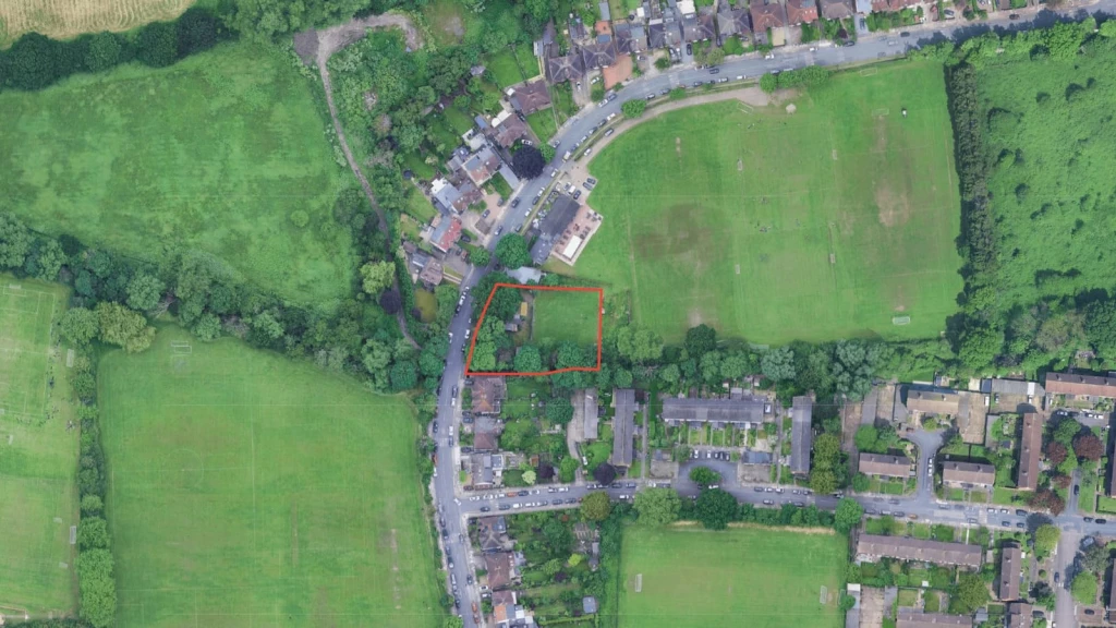
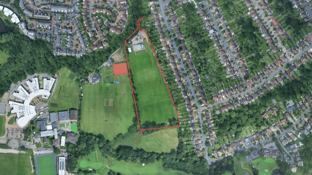
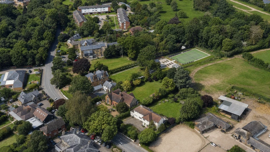
Four homes were allowed in principle after an inspector treated MOL as Grey Belt. This is the decision that started the debate, so it is worth reading carefully.
The appeal was a permission in principle that sought four 4-bedroom dwellings on former tennis court land and associated hardstanding within MOL at Angsamus, Weigall Road, Greenwich, to the south-west of the Crofton Albion Sports and Social Club.
The Inspector applied London Plan Policy G3 and Greenwich Local Plan Policy OS2, and concluded that the NPPF Green Belt framework applied to this MOL site.
The land was constrained by recreation land, the River Quaggy, Weigall Road, and existing housing. It made a useful but not strong contribution to checking the unrestricted sprawl of large built-up areas under paragraph 143(a).
There was no substantive evidence before them that the site strongly contributed to preventing neighbouring towns from merging, or to preserving the setting and special character of historic towns. They had not been referred to any footnote 7 policy that gave a strong reason to refuse. On that basis, they found the site to be grey belt land.
With Greenwich's five-year housing land supply reported at 2.46 years, an accepted sustainable location, and a small-scale proposal that would not fundamentally undermine the remaining Green Belt, they found that criteria (a) to (c) of paragraph 155 were met. Criterion (d) was not relevant, because the proposal was not major development.
Having concluded that the scheme was not inappropriate, they expressly stated that they did not need to consider the effect on openness. I return to that point in the openness section.
Because the appeal was for permission in principle, the only matters considered were location, land use and amount. The technical details were reserved. That did not make flood risk, ecology, access or other fundamental constraints irrelevant. At permission in principle stage, there must still be sufficient evidence that development is acceptable in principle.
This matters because it converts a previously academic argument into a live route that inspectors will now test on the facts. It does not mean that MOL is Green Belt, or that all MOL is now Grey Belt. The inspector assessed one defined, constrained parcel and made an evidential finding about that site, not a ruling that MOL can never contribute to the Green Belt purposes. On a different site, with different evidence, the answer could go the other way.
The lesson from this appeal is narrow. A Grey Belt argument is no longer automatically unavailable on MOL, but the layout, design, flood strategy, ecology and access were all left to a later stage, where any of them could still defeat the scheme. Eligibility is not consent. But the decision does not make all openness questions disappear. It shows that openness matters at different stages, depending on the route relied upon.

Openness is often reduced to a visibility exercise. That is too narrow, and misstates where openness does its work.
A building can be largely screened by trees or fences and still reduce spatial openness, because it occupies land that is currently free from built form. Equally, a proposal may be visible from public places but have a limited effect, where it sits within an established built context and does not change the spatial relationship of development and open land in a material way.
There is an important refinement that is often missed, and the Greenwich appeal is a live illustration of it. Where a proposal genuinely falls within a Green Belt exception, or qualifies under the Grey Belt route, it is not inappropriate development. The courts have confirmed that openness is not then a separate, free-standing test to be assessed afterwards.
In Mole Valley District Council v Secretary of State [2025] EWHC 2127 (Admin), the High Court held that for development which is not inappropriate, including qualifying Grey Belt schemes under paragraph 155, there is no residual test of harm to openness. Once the Greenwich inspector found the scheme qualified under paragraph 155, she declined to assess openness at all. That sequencing is now settled at High Court level.
Openness still carries decisive weight in two places. It decides whether several of the paragraph 154 exceptions are met at all, because many of them require openness to be preserved or not substantially harmed. And it sits at the heart of the Very Special Circumstances balance.
So the right question is rarely whether openness is harmed in the abstract. It is whether the proposal fits a route, and what that route requires on openness. With that framing in mind, the way openness is assessed normally has four parts.
This is about the physical presence of development.
How much land is occupied now, and how much would be occupied after development? How do footprint, height, volume, hardstanding and built spread change? Is the proposal concentrated in an established developed area, or does it move into land that is presently open? Does the arrangement fragment an open area or introduce new enclosure?
This concerns what people can see and experience.
Relevant viewpoints may include public roads, footpaths, parks, waterways, bridges, neighbouring public spaces and entrances to open land. Winter views often matter as much as summer views, where screening depends on deciduous vegetation.
But visual impact is not the only test, and a proposal should not rely on planting alone to solve a spatial openness problem.
Traffic, lighting, parking, outdoor seating, storage, fencing, deliveries, events and intensified use can all affect the perception and functioning of open land.
They may also trigger other policies, especially on amenity, ecology, transport and flood risk.
The starting point should be factual. A lawful existing building, an extant permission or a realistic fallback can all be relevant.
The fallback must be more than a theoretical possibility, and its effect on openness must be genuinely comparable. A weak fallback often fails because it is lower, smaller, less visible or materially less intensive than the proposal. A planning history is helpful only when it is analysed with the same discipline as the new scheme.
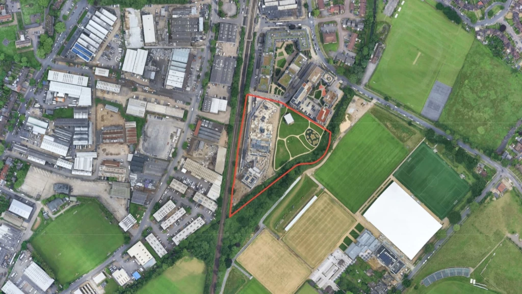
A major MOL scheme was allowed through a quantified baseline and an exceptional public benefit package. It shows what a winning case at the demanding end of MOL actually looks like.
The proposal was the demolition of existing buildings and redevelopment to provide 254 homes in buildings of four to eleven storeys at Footzie Social Club, Station Approach, Lower Sydenham, in the London Borough of Bromley.
The site was designated MOL, and the Inspector treated the built component as inappropriate development requiring Very Special Circumstances.
The former sports ground contained permanent buildings and hardstanding, and the Inspector recorded that part of the site was previously developed land.
New buildings, access, parking and private amenity were kept within roughly a third of the site, with the remainder laid out as public open space. The scheme was assessed against an extant 2019 residential permission. The inspector concluded that it would have no greater impact on the spatial dimension of openness than the existing development and the extant scheme.
The benefits package included the new homes, a substantial affordable housing contribution, public open space, river bank planting, biodiversity and appearance improvements, and a public route that filled a missing Green Chain and Waterway Link connection. These were secured through planning obligations, and the inspector found that they clearly outweighed the harm.
Footzie is not a precedent for dense housing on MOL in general. It is a reminder that a strong MOL case must be built on a credible comparison. The winning strategy was not simply that the land was brownfield. It measured the developed baseline, used a real fallback, contained the built footprint, retained public open space, and secured a package of benefits the inspector found decisive.
The decision predates the current NPPF and was made under the framework then in force. Treat it as a lesson in evidence and planning balance, not as a formula.
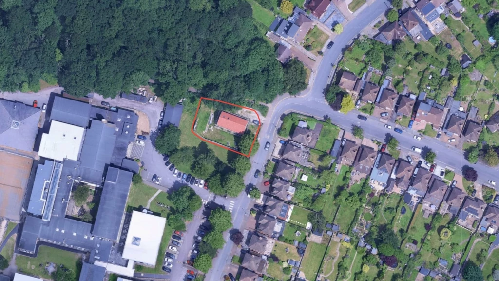
Limited openness harm was still not preservation of openness. This is the small-scale warning that sits at the opposite end from Footzie.
The proposal was the conversion of a garage and store into a cafe, with a canopy over external seating, for use when sports and recreational activities took place at the club, at L A Sports Club, St Dunstan's Lane, Beckenham.
The inspector accepted that the cafe and seating could be an appropriate facility in connection with outdoor sport and recreation. But the exception also required the proposal to preserve openness.
The canopy extended beyond the former garage footprint, increased the amount of land covered, and introduced replacement surfacing and commercial paraphernalia. The inspector found limited spatial and visual harm, and then concluded that limited harm was not the same as preservation of openness.
The scheme also failed the extension exception, because the canopy was a disproportionate addition to the original garage. It failed the replacement building exception too, because it was a conversion to a different use rather than a replacement building.
The site was in Flood Zone 2, and no flood risk assessment had been submitted. The inspector gave only moderate or limited weight to the claimed community and financial benefits, because the evidence did not show that the facility was necessary or that it could not be accommodated in the existing clubhouse. The appeal was dismissed.
This is a valuable small-scale warning. A sports or community label does not exempt a proposal from the full policy test. A scheme can be functionally connected to sport and still fail because it does not preserve openness. It also shows why every technical issue must be addressed early. An otherwise modest proposal became harder to defend because the flood risk evidence and the operational case were incomplete.

Grey Belt policy has created understandable interest among owners of constrained, underused and developed land. It has also created a risk of overstatement, and the Greenwich appeal has amplified both. The subsections below set out what Grey Belt actually means, whether it reaches MOL, why eligibility is only the first gate, and what an MOL Grey Belt case must prove.
The NPPF defines Grey Belt as land in the Green Belt comprising previously developed land, or other land that does not strongly contribute to any of Green Belt purposes (a), (b) or (d), subject to the exclusion for land affected by footnote 7 policies that provide a strong reason to refuse or restrict development.
One point is easy to miss. Grey Belt land is still Green Belt land. It is simply Green Belt land on which qualifying development is treated as not inappropriate under NPPF paragraphs 153 and 155. It is not a new designation that removes protection.
The common error is to reverse the analysis. MOL was not designated because it had to satisfy the five Green Belt purposes, so the question is not whether every MOL site can be shown to fail them. The real question on an MOL site is whether Policy G3 makes the paragraph 155 route available, and whether the evidence shows that this particular site meets the Grey Belt test and every other paragraph 155 requirement.
Notice also which purposes are in play. The Grey Belt definition tests only purposes (a), (b) and (d) of paragraph 143. It does not test purpose (c), safeguarding the countryside from encroachment, or purpose (e), assisting urban regeneration. So an argument that there is little MOL on London's periphery, or that golf courses help recycle land, is beside the point. Those are not the purposes the test asks about.
Do not use shortcuts. A site being enclosed by development may be relevant to purpose (a), but it is not conclusive. A site within Greater London may still help prevent separate settlements from coalescing, and may still contribute to the setting or special character of a nearby historic place. These are landscape and planning judgments based on the real site, its context and the evidence.
This is now the most contested question in MOL planning, so let me answer it directly. The question of whether MOL can be Grey Belt has two honest halves, and most commentary only gives you one of them.
Here is why it can.
Policy G3 gives MOL the same protection as Green Belt and applies the national Green Belt tests to inappropriate development. The Grey Belt route in paragraph 155 sits inside those tests. So where the policy bridge holds and the evidence supports it, an inspector can treat an MOL parcel as Grey Belt. The 2026 Greenwich appeal, set out as the Angsamus case study earlier, is the clearest example to date.
Here is why it cannot, at least not as a class.
MOL is not relabelled as Grey Belt by the adopted London Plan. The definition is written around land in the Green Belt, and it reaches MOL only through the Policy G3 bridge, which is under review and may be severed. The definition also carries a footnote 7 filter that excludes much of London's most valued open land at the outset. And even where a site qualifies, eligibility is not consent.
The safer way to hold the position is this.
MOL and Green Belt remain distinct designations.
London Plan Policy G3 applies the national Green Belt tests to inappropriate development on MOL.
The NPPF and its Planning Practice Guidance are written in terms of Green Belt.
The Greenwich decision shows an inspector may treat an MOL site as Grey Belt for the paragraph 155 route, where the policy bridge and the evidence support it. But that turns on the specific site, the proposal being considered, and on the policy in force when the application or appeal is decided.
There is a filter inside the definition that the headline version ignores. Footnote 7 is not a generic environmental bar. It concerns the application of NPPF policies covering Habitats sites, SSSI, National Landscapes, National Parks, Heritage Coast, irreplaceable habitat, designated heritage assets and certain archaeological assets, and flood or coastal-change risk.
A protected-species issue or local designation must be assessed in its own right. It does not fall within the Grey Belt exclusion unless it engages a Footnote 7 policy that provides a strong reason to refuse or restrict development.
It is also why the headline number overstates the case. London's MOL is often cited at around 15,000 hectares, and the viral reading turned that into a figure of around 750,000 homes. Fifteen thousand hectares is a map, not a development pipeline.
That sum ignores how much of the land is excluded from the route at the definitional stage, the second gate where open space, sport, ecology, flood and heritage policy decide most outcomes, and the gap between theoretical capacity and a deliverable consent on a real site. The careful reading of Greenwich is narrower. One small, enclosed, degraded parcel of MOL qualified as Grey Belt for one exception. That is a real finding, not a verdict on 15,000 hectares.
The meaning of the definition is itself being worked out in the courts. In Wrotham Parish Council v Secretary of State [2026] EWHC 165 (Admin), the High Court was asked whether Grey Belt status attaches to the land as a whole or to the specific scheme, and whether the footnote 7 question is judged against the proposal or against development generally on the site. A definition that is being litigated this finely is the opposite of a settled land grab.
There is one further caution. As set out earlier, the Mayor has proposed severing the very link in Policy G3 that lets the Grey Belt route reach MOL. Anyone relying on that route for an MOL site should treat it as a route that exists today on current policy, not as a durable position.
This is the point I would press hardest, because it is where most of the recent enthusiasm goes wrong. A Grey Belt argument can succeed at the first gate and still fail at the second.
Gate one is the Policy G3 and paragraph 155 route. It requires a site-specific assessment of contribution to purposes (a), (b) and (d), the footnote 7 constraints, demonstrable unmet need, the sustainability of the location, the effect on the remaining Green Belt, and, where relevant, the Golden Rules.
Gate two is the rest of the planning and delivery case, and on most valuable MOL sites it is the harder gate.
MOL sites may also be protected by open space, playing field, sports, ecology, flood risk, heritage, tree, transport or public access policies. Any one of them can defeat a scheme that sailed through gate one.
A significant share of London's MOL sits under statutory regimes, charitable or recreation trusts, restrictive covenants, leases or access rights. Much of it is held by bodies such as the Crown and the City of London Corporation. No Grey Belt argument touches any of that.
That is why the most high-profile MOL sites are rarely simple Grey Belt propositions. A proposal may have an arguable route through Policy G3 and still be unacceptable, undeliverable or commercially unwise once the other layers are tested. You can win the argument and still lose the site.
An MOL Grey Belt case needs far more than a photograph of a disused yard or a description of a constrained site.
At a minimum, the evidence should address the contribution to checking the unrestricted sprawl of large built-up areas, the contribution to preventing neighbouring towns from merging, the contribution to the setting and special character of historic towns, whether a footnote 7 designation creates a strong reason to refuse or restrict development, whether the development would fundamentally undermine the purposes of the remaining Green Belt across the plan area, the demonstrable unmet need for the type of development proposed, the sustainability of the location, and the Golden Rules where applicable.
It is a demanding exercise. But it is far more useful than treating Grey Belt as either a guaranteed route or a complete irrelevance. And it is still only gate one.
Private garden land, ecology measures, and a fallback position did not outweigh MOL harm. This is the case that shows gate two doing its work even where the principle looked arguable.
The proposal was a two-storey self-build dwelling within part of the garden and adjacent incidental land associated with an existing house at 2 Somerford Way, London SE16.
Only the proposed new dwelling was within MOL and a Site of Importance for Nature Conservation. The planning inspector found that it did not fall within any relevant exception and was inappropriate development.
The land was reasonably open despite being private and partly within a domestic curtilage. It formed a transition between existing housing and Russia Dock Woodland and allowed views towards the woodland.
The ecological assessment was accepted as showing no harm to nature conservation, and biodiversity measures could have been secured. Those points did not answer the separate MOL openness issue.
A permitted development fallback for a single-storey outbuilding was found to be realistic. But it was materially smaller and lower than the proposed two-storey house, so its effect on openness was not broadly the same or better.
A satisfactory legal agreement was also required for biodiversity and affordable housing obligations, which showed that technical and legal delivery points can stay live even when the principal MOL issue is decisive. The appeal was dismissed.
Private ownership and domestic use do not make MOL policy disappear. Nor does a site become suitable for a house simply because it is screened, inaccessible to the public, or capable of accommodating a smaller outbuilding. The strategic lesson is to test the exact proposal against the adopted boundary and the real fallback, then deal with ecology, housing obligations and other policies as separate workstreams.
MOL is often associated with sports clubs, former recreation grounds, schools, golf-related land, riverside spaces and institutional holdings. These sites may carry public benefit narratives, but they also attract additional policy obligations. The two subsections below separate the questions to ask on a sports or recreation site from the features that actually give a benefit weight.
Before you rely on a public benefit case, work through the obvious lines of objection.
Is the existing facility protected by an open space, playing pitch or sports policy?
Is there evidence that the land is surplus to requirements?
Would the proposal remove a facility, fragment a pitch or reduce recreational capacity?
Is any replacement facility genuinely equivalent, deliverable and secured?
Does the proposal improve public access, biodiversity or green infrastructure in a way that is additional and permanent?
Could the claimed benefit be delivered without the proposed built form?
The last question matters most. Decision makers often give less weight to a benefit where there is no evidence that it could not be achieved through a smaller building, a different location, an existing clubhouse, or a less harmful use of land.
Public benefits are strongest when they are direct, measurable and tied to the proposal.
Examples may include a publicly accessible path, restored habitat, secured public open space, a funded sports facility, genuinely affordable housing, infrastructure works, or a credible reduction in an existing harmful condition. A future aspiration, a general claim of local economic activity, or an uncosted promise usually carries less weight.
This is also where the golf-course argument needs handling with care. Private ownership, restricted public access, low participation, or commercial underperformance do not make a golf course, playing field or managed landscape previously developed land.
A clubhouse, maintenance yard, car park or hardstanding may create a developed baseline, but the wider recreational land must be assessed separately. A golf course does not become brownfield by rhetoric.
Those factors may be relevant to a plan-led review, to the weight of claimed public benefits or to the future management of the land. They are not an application-stage exception from MOL policy.
The All England Lawn Tennis Club's Wimbledon Park scheme is the clearest illustration of why permission and deliverability are not the same thing. The site is a former private golf course, designated MOL and a registered historic landscape, and the case leaned heavily on public benefit, including new public parkland on land closed to the public for decades, alongside the sporting and economic value of the Championships.
The Mayor granted permission in 2024. The consent has since been challenged by judicial review, a separate High Court dispute over whether the land is subject to a statutory public recreation trust has run alongside it, and restrictive covenants over the land remain unresolved
Its procedural history will keep moving, so do not treat the latest twist as the lesson. The enduring point is structural. A major public-benefit case on MOL has to work across every relevant planning and legal layer at once, including ownership, statutory rights and private-law restrictions, not simply overcome the MOL designation. It is a heavily contested, benefit-led and fact-specific case, and the opposite of a template for ordinary residential development.
MOL is not the only designation that turns an open-looking plot into a planning problem. London's boroughs protect a wider family of open land, and one of the most common is Urban Open Space, usually shortened to UOS.
UOS and MOL are different designations. They sit in different documents, carry different protection, and are tested against different policies. MOL is a strategic London-wide designation that borrows Green Belt protection through Policy G3. UOS is a local designation, defined in a borough's own Local Plan, with its own criteria. Do not assume that a Grey Belt argument, a Green Belt exception or the Very Special Circumstances test has any role on a UOS site. Usually it does not.
What they share is the planning challenge, not the legal test. On both, the council's first concerns are the same: The loss of openness. The visual enclosure of a space that currently reads as open. Harm to landscape character. The effect on biodiversity and public value. And the cumulative erosion of protected open land, one plot at a time.
That shared challenge means the winning approach is shared too, and it is not the one most owners reach for first. Arguing that a site is underused, scruffy or previously developed rarely carries a UOS or MOL case on its own. The stronger route is to make the proposal demonstrably restrained, well positioned, and supported by a clear planning balance.
In practice that means doing the hard design work before the application, not after the refusal. Reduce the built footprint. Retain meaningful open areas rather than filling the plot. Locate new built form away from the sensitive edges and the public views, not on them. Strengthen landscaping and biodiversity so the scheme gives something back. And show, with evidence, that the benefits clearly outweigh whatever limited harm remains.
The thread that runs through every successful case in this guide applies here too. Treat a UOS or MOL site as a sensitive planning case from the outset, with design, landscape and planning strategy working as one. The schemes that win are the ones where the restraint is built into the drawings, not bolted on to the planning statement afterwards.
This one is ours, and restraint won the case.
The site was School House, Avebury Road, in the London Borough of Bromley. A small, substandard post-war house sat on a suburban plot of around 500 square metres, designated Urban Open Space in the Bromley Local Plan. The council had resisted redevelopment because of that designation.
Our client wanted two well-proportioned semi-detached homes instead.
We set the houses at right angles to the street, broadly held the depth of the existing house, and pushed most of the additional built form away from the street. The net loss of undeveloped land was just 24 square metres. New trees, shrubs and rain gardens strengthened the planting, biodiversity and landscape value.
Bromley refused. They won on appeal. The inspector found the harm to the Urban Open Space limited, and concluded it did not outweigh the benefit of two well-designed homes.
MOL should change the way you assess a purchase. It should not automatically end the deal.
The core commercial question is whether the property has a credible, deliverable planning route at a price that reflects the risk. That cannot be answered safely from a title plan, a marketing brochure or a vague statement that there may be development potential.
Before exchange, an option agreement or major design expenditure, work through the seven steps below. This is the kind of due diligence that decides whether an MOL site is an opportunity or a trap.
Confirm designations and boundaries: Check the adopted borough policies map, London Plan mapping and the exact designation boundary. Identify other constraints, including open space, SINCs, flood risk, heritage, trees, views and rights of way.
Review the planning history: Obtain decision notices, previous drawings, conditions, legal agreements, enforcement records, LDCs and appeals. Establish what has been built, lawfully implemented, expired or remains unresolved.
Establish the existing baseline: Record the site’s actual footprint, floorspace, height, hardstanding, access, parking and activity through a measured survey, photographs and historic evidence.
Test the planning route before designing: Consider whether there is a credible route through paragraph 154, Grey Belt, redevelopment of previously developed land, reuse, appropriate facilities, or Very Special Circumstances. A full design will not overcome a weak policy case.
Check title, access and legal constraints: Review rights of way, covenants, easements, shared access, services, lease restrictions and other private-law issues alongside the planning assessment.
Identify technical risks early: Flooding, biodiversity, trees, heritage, drainage, ground conditions and highways may determine whether a scheme is deliverable.
Reach a clear commercial conclusion: Work with chartered architects and town planners experienced in MOL and Green Belt development to identify a realistic route forward. Proceed where there is a credible planning case and manageable constraints; pause where further evidence, legal clarification or technical work is needed; and do not proceed where there is no realistic route to planning permission or delivery.

The strongest applications are built around the actual policy route, not around a broad claim that the proposal is sustainable or sensitive. Here is how to assemble that case in the right order.
A good Design & Access Statement for a proposal in MOL should not begin with a generic quotation from Policy G3.
It should explain the exact designation and adopted policy context, the physical and lawful baseline, the specific paragraph 154 exception, paragraph 155 Grey Belt route, or Very Special Circumstances case relied upon, the effect on spatial and visual openness, the local policies that apply alongside MOL, the evidence supporting each claimed benefit, and how mitigation and benefits will be secured.
On a MOL site, planning drawings are part of the argument rather than presentation extras. At a minimum, consider the following.
Existing and proposed site coverage plans.
Building footprint, height and volume comparisons.
Verified views from public and sensitive locations.
Sections showing the proposal against landform, trees and adjacent development.
Plans distinguishing permanent development from temporary structures.
An opportunities and constraints plan, and a landscape and open space strategy where relevant.
The right consultant team depends on the site and may include ecology, arboriculture, flood risk and drainage, heritage, transport, landscape, daylight and sunlight, noise, viability, energy and biodiversity net gain specialists.
Your architect and town planner should act as lead consultant, advising on the right strategy, scope of work and timing for each specialist, and ensuring the evidence supports a coherent planning case and design response.
The key point is timing. Technical evidence should be commissioned early enough to shape the proposal, rather than only once an objection has been raised. A late report may show that harm can be reduced, but it will not always rescue a scheme whose planning route was unclear from the outset.
For MOL cases, we always seek pre-application advice once a credible planning route has been identified. Across the successful consents we have secured for complex proposals, early engagement has been valuable in testing the issues that usually determine the outcome, including openness, previously developed land, sport, heritage, flood risk and design.
Pre-application engagement is not a substitute for preparation. A weak submission at pre-application can establish an unhelpful narrative that carries through to the planning stage. A strong one defines the real policy question, presents the necessary evidence and asks targeted questions that shape the design, consultant work and application strategy that follow.
At Urbanist Architecture, our role is not simply to respond to constraints, but to find the strongest route through them. We bring planning, design and technical evidence together from the outset to turn difficult MOL sites into clear, credible and deliverable proposals.
A refusal is not the end of the project. But a planning appeal is not automatically the right answer either. The decision turns on one question: why did the proposal fail?
That answer lies in the documents. Assess the case on the refusal notice, the officer report, the consultation responses, the drawings, the submitted evidence and any material policy changes. Read together, they show whether the refusal was sound or flawed, and that distinction sets the route.
Where the refusal rests on a correct but avoidable issue, such as poor siting, excessive scale, missing technical evidence or incomplete obligations, a revised application is usually the stronger route. It fixes the problem rather than arguing around it.
An appeal to the Planning Inspectorate becomes the better option where the council has misunderstood the policy route, misapplied the evidence, failed to recognise a credible fallback, or reached an unreasonable conclusion on a focused issue. Weigh the costs risk before committing. A full or partial award follows only where a party's conduct was unreasonable, and that standard cuts both ways. It can expose an appellant pursuing a weak appeal just as readily as it exposes a council.
MOL cases demand more. The strategy should never be that the council was simply too strict. The better question is whether the appeal can demonstrate a clear policy route, answer the identified harm, and resolve every other issue at the same time. Win on all three and the appeal stands. Miss one and it fails.
In my experience, the projects that succeed on MOL treat the designation as the first question, not the last. The owners who struggle are usually those who fall in love with a design, or a headline price, and then look for a policy route to justify it. On strongly protected land, that order rarely works.
I would describe the Greenwich decision as a breakthrough planning argument, not a guarantee of planning permission. It means owners of constrained, under-used or partly developed MOL sites should no longer be told that Grey Belt is irrelevant simply because the policy map says MOL rather than Green Belt.
But it would be equally poor advice to say that MOL has been neutralised. The first task is to test whether Policy G3 and paragraph 155 genuinely create a route on the facts. The second is to test whether the proposed development survives the policy, technical, legal and commercial constraints that often matter more than the MOL designation itself.
Set against the wider run of recent Grey Belt appeal decisions, the pattern is clear enough. The route is genuine, but it is fact-sensitive and far from settled, and on MOL it depends on a bridge that may not survive the next London Plan.
That is why a genuine previously developed land baseline, a reuse case, a carefully controlled replacement strategy or a credible Very Special Circumstances package may sometimes be more durable than a Grey Belt argument alone. The strongest strategy is the one that still works after the excitement around a single appeal has passed.
The most valuable early spend is almost never a full design. It is a focused appraisal that tests the route, the baseline and the secondary constraints, and then tells you honestly whether to go, pause or walk away.
MOL is a serious constraint. It protects land that often performs important strategic, recreational, landscape or environmental functions in London, and it should never be treated as a planning loophole.
At the same time, the designation does not make every proposal impossible. The Greenwich appeal has confirmed that, and sharpened the argument available to the right kind of site. Existing development, previously developed land, reuse, carefully controlled replacement or extension strategies, Grey Belt arguments in the right circumstances, and genuinely exceptional benefit cases may all create a route.
The difference lies in the early questions. What is the baseline? Which policy route is actually available, and is it durable given the changes now in consultation? Does the site clear the first gate, and can it survive the second? What harm must be addressed, and which benefits are specific and deliverable?
Planning outcomes on MOL are site-specific. They depend on the planning history, the local policy position, the constraints, the design, the evidence and the council's assessment, and the safest course on a complex site is to take advice before committing money or making decisions.
On MOL, the cheapest mistake is the one you make before you have tested the route. The most expensive is the one you make after you have fallen in love with the design.
Before you commit to a purchase, major design costs or a planning application, the sensible first step is usually a planning feasibility assessment that tests both gates against the adopted policy, the planning history and the physical evidence. That early appraisal is usually the quickest way to decide whether a site deserves further investment, and it is where a viable route gets separated from a hopeful one.
We look forward to learning how we can help you. Simply fill in the form below and someone on our team will respond to you at the earliest opportunity.
The latest news, updates and expert views for ambitious, high-achieving and purpose-driven homeowners and property entrepreneurs.


We specialise in crafting creative design and planning strategies to unlock the hidden potential of developments, secure planning permission and deliver imaginative projects on tricky sites
Write us a message